February 21, 2025
SkyTruth: Exposing a dark reality spilling into our seas
BY: Sophie Fresson
Topics: Oil and Gas
Estimated reading time: 5 minutes
Believe it or not, the ocean is awash with toxic oil pollution. Slicks, pipeline leaks, accidental discharges, tanker spills… chronic oiling comes from a multitude of sources. We spoke to John Amos, CEO of SkyTruth, on using new technology to expose a dark reality. See the reality of Big Oil’s chronic pollution of our seas using Oceana UK’s live oil spill map, updated using the government’s own data. If this makes you angry, you can take action here.
Q: How do you detect oil slicks from space?
Our system, Cerulean, scans every radar satellite image collected by the European Space Agency, searching for oil slicks. Using AI, we train it to detect slicks just as our human analysts would, and then we map them. While not as perfect as a human analyst, Cerulean is extremely efficient, scanning about 1,000 images per day – something that would require at least a dozen humans to match. The beauty of having a machine-learning model is that we can continually train it, so its analysis gets smarter over time. We know that chronic and persistent oil pollution is happening in the North Sea. We aim to use this technology to make this data accessible globally, raising awareness of an issue many people don’t even know exists.
Q: Is the North Sea especially bad for oil slicks?
We initially assumed that countries in Northern Europe, with strong regulatory systems and environmental ethics, would mitigate oil pollution effectively. However, a study with Oceana UK and Uplift revealed a different reality. We examined 18 rigs in the UK sector of the North Sea over a year and found repeated oil spills from each platform. This appears to result from the routine discharge of ‘produced water’ – into the ocean. Shockingly, the concentration of oil in this discharged water is high enough to create slicks visible from satellites in space 250 miles above.
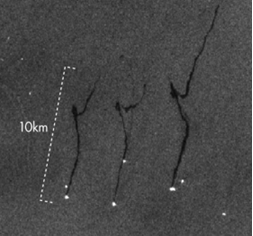
In this image we can see at least three platforms (bright spots) that have long, dark slicks trailing to the north, each about 10 kilometres long. Whether you’re in a boat, or you’re a dolphin in the water, a 10km long oil slick is not a trivial feature to come across.
Q: ‘Produced water’ sounds quite harmless, though?
Produced water is essentially a chemical soup with residual oil. In many regions, including the UK, companies discharge this byproduct of oil and gas production directly into the ocean. Along with accidental leaks and spills, and the direct disposal of drill cuttings on the seafloor, this intentional chronic pollution causes dead zones around North Sea platforms. While the localised impact is well-documented, the broader effects on fish spawning grounds, shellfish nurseries, and whale migration paths remain harder to study. The long-term toxic load could have far-reaching consequences.
Q: How do you determine if it’s an oil slick, and whether its human-caused?
We train the model to differentiate between and ignore natural factors that could mimic an oil slick. For instance: thin polar ice, large seaweed mats, certain surface wave patterns or heavy rainfall. We can tell then tell if a slick is human-caused based on the location and the patterns we see on the ocean surface. Natural oil seeps usually occur in clusters on the seafloor. Oil droplets floating up to the surface from a cluster of seeps create multiple strands of oil slick, that often coalesce as the wind and currents move them. In contrast, a leak from an oil platform typically has a distinct, single source. Cross-referencing slick locations with known oil rig positions provides additional confirmation. The one thing we can’t conclusively tell from space is what type of oil it is.
Q: You used to work in oil and gas. What made you switch to environmental advocacy?
I worked as an exploration consultant for nearly a decade, conducting studies for oil and gas companies. But my perspective shifted. I became convinced that climate change was real and decided I didn’t want to contribute to the problem. I realised that satellite imagery could reveal stark environmental stories – things happening in remote areas that most people were unaware of.
I wanted to make the invisible visible, hoping it would inspire people to care and hold those responsible accountable.
Q: How do oil and gas companies react to environmental issues?
Big Oil is not one monolithic entity; it’s thousands of companies, each with its own approach. Some are proactive, others less so. I can’t name the company involved but I do have a telling anecdote from when I worked as an exploration geologist. I’d noticed a persistent oil slick in the Gulf of Mexico above a pipeline. When I informed a contact at the operating company, they confirmed the leak but hadn’t fixed it. Months later, the slick was still there on satellite imagery. When I followed up with the contact, he said the response he’d gotten from the engineering team was: “We know about the leak. Now stop bothering us.” Their decision came down to cost. Fixing the leak wasn’t financially justified since they weren’t losing enough oil to make it worthwhile.
As long as no regulator notices and fines them, some will prioritise profit over environmental responsibility.
And I wouldn’t expect many companies to operate any differently, whether they are oil companies, Big Agriculture, or clothing manufacturers. That’s how capitalism works.
Q: What’s your ultimate goal with SkyTruth’s work?
By making these problems visible, I hope to drive change to protect the planet. We need to ask hard questions of the people responsible. We’re talking about companies in an industry that is making billions in profit every year. So, the continued sloppy operations that result in chronic and persistent oil pollution are inexcusable.